You are here
Tell Hisban through ages
By Saeb Rawashdeh - Jun 09,2024 - Last updated at Jun 09,2024

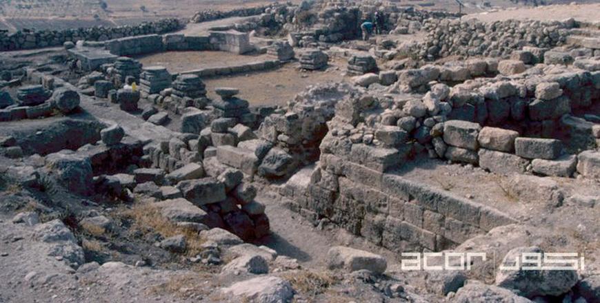
A structure seen at Tell Hisban, a site in the Madaba Plain (Photo courtesy of ACOR)
AMMAN — The archaeological team from Andrews University excavated for more than 50 years the site of Tell Hisban, in the middle of the fertile Madaba Plain. The site and the area have been occupied since the Bronze Age. In the Roman period a road led from Tell Hesban (Esbus ) to Tell er-Rameh (Livias) in the Jordan Valley
The Bronze Age sherds were again found when digging at Umm es-Sarab, and they were only in mixed contexts; only the Early Roman and Byzantine periods were actually represented by strata in the two trenches completed to bedrock, said Professor Emeritus Lawrence Geraty.
“To the southwest one sees Mount Nebo, from which, according to traditional narrative, Moses viewed the Promised Land [Deut. 34], and Madaba is also seen in from a far,” Geraty noted.
From the ancient times, the area was known as a bread basket due to wheat fields and the big water reservoir was also seen but obviously, it was no longer used by the 2nd century BC.
One can still see a major fortification wall built through this area shortly thereafter in the Late Hellenistic period as well as a massive lime kiln from the Byzantine period, probably used in connection with the construction of a Christian church on the summit, Geraty elaborated, adding that to the east of the reservoir one can see the remains of numerous habitation caves and storage pits carved out of bedrock, most of which were probably destroyed in 31 BC by the earthquake.
Over all the above features to be seen in Area B is a sequence of plaster layers and their soil make-up (still to be seen in section, in the sides of the squares) which the supervisor has interpreted as a series of roadways first built in Early Roman times and continuing for 400 years into the Byzantine period.
“This route probably served as the major approach to the acropolis, and one may still see the remains of bases or pedestals that may have been for shrines along the original roadway. As we climb the path to the acropolis along the east edge of the excavations we pass our Area D, the ancient southern access route. We can see more of the caves and storage pits cut in bedrock that we already saw in Area B and remnants of Roman architecture,” Geraty noted, adding that on the left standing is part of a flight of monumental stairs from Late Roman times that orginally led right up to a gateway through the acropolis perimeter wall— an imposing cyclopean wall that we can still see.
In still later times, there were vaulted rooms that probably served as part of a caravanserai, the remains of which can now be seen only in the balk , and storage rooms that are recently excavated by international archaeological teams.
On the foothills, the foundations of a Christian church from the Byzantine period (about the 4th -6th centuries AD can be seen.
“In plan, it is a typical basilica, its apse oriented towards the east, with a wide nave separated from the two side aisles by stylobate walls, each provided originally with at least five columns. Under the church in the northeast corner, one sees a doorway leading to a large cave, over which the church was built,” Geraty explained, adding that the cave’s exact use is still undetermined.
North-eastern corner of the church was cut in the 7th -8th century AD to make a hole where the Umayyad Arabs built a large tabun, or ceramic oven, complete with stone and-plaster pipe opening into its western side.
“Another, even later Arab structure (from the Mamluk period just after the Crusades), now hides the narthex of the church and by far the most interesting structure we have found from this particular period, it is the best-preserved Mamluk bath complex,” the professor underlined.
The remains of a furnace room, warm and cold water tanks situated above and to the side of the stoke hole can be seen as well as a heated tile-floored bathroom containing a stone basin into which the water ran through pipes in the wall
A Mamluk domestic housing complex, complete with plastered floors, fine thresholds, courtyards for animals, cisterns and so forth is located on the easternmost part, but as “we move to the west, where the depth of occupation becomes deeper [and earlier], we see clinging to the contours of bedrock the remnants of what was probably the Iron Age city’s zigzag defence wall, at least as late as the 7th -6th centuries BC”.
As we can testify by touring the site, Tell Hisban has a continuous occupation from Bronze and Iron Ages, Hellenistic, Roman, Byzantine, Ummayad, Mamluk and Ottoman times.

Related Articles
AMMAN — A recently published book titled “Hisban” offers insight into archaeological sites of the area of the Madaba plains and interactions
AMMAN — Tell Jalul, located 5km east of Madaba, is the largest tell( hill or mound) that covers 7.2 hectares in central Jordan, said Paul Ra
AMMAN — Tell Umayri is an archaeological site located approximately 12 kilometres south of Amman.

Opinion

Jul 08, 2024
Jul 08, 2024
Jul 08, 2024

Jul 06, 2024
- Popular
- Rated
- Commented
Jul 08, 2024
Jul 08, 2024
Jul 08, 2024
Jul 06, 2024


Jul 08, 2024

Newsletter
Get top stories and blog posts emailed to you each day.