You are here
Archaeological Project Sheds Light on Ancient Water Management in Udhruh
By Saeb Rawashdeh - Oct 19,2024 - Last updated at Oct 19,2024

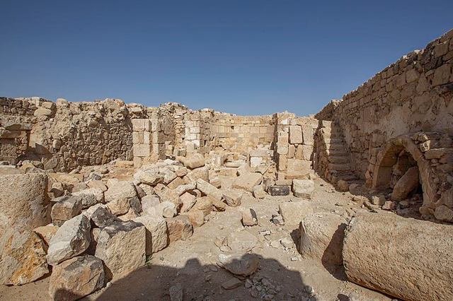
The interior of the Ottoman fortress at Udhruh (Photo of Bashar Tabbah)
AMMAN — Professor Fawzi Abudanah from Al Hussein Bin Talal University in Maan conducted survey at Udhruh, a site located some 15 kilometres east of Petra.
Abudanah initiated partnership with Professor Mark Driessen from University of Leiden in The Netherlands and Udhruh Archaeological Project was launched in 2011.
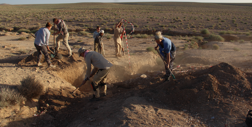
Teams of Jordanian and Dutch archaeologists explored the area and reconstructed the water harvesting in a very arid area of Udhruh.
Climate conditions
Access to fresh water is one of the greatest global challenges of the 21st century and it was a challenge for ancient inhabitants of Petra hinterland.
"Scholars from different fields of research around the world are dealing with the ever-growing demand for, and the severe supply constraints upon, water. Rapid population growth and changing climatological conditions, especially in some of the most water-scarce regions of the world, result in increasing pressures on already overexploited water resources," Driessen explained.
He added that this is especially the case in the arid and semiarid parts of the Middle East, North and sub-Saharan Africa, where almost all the water is used for agricultural purposes.
Not only is the annual precipitation in such regions low and poorly distributed over the crop-growing seasons, but a large part of it gets lost before it becomes available for agricultural use, Driessen continued, noting that in semi-arid regions of sub-Saharan Africa, between 30 and 50 per cent of the precipitation evaporates from the soil surface and after shallow infiltration, and can be considered non-productive water loss.
A productive transpiration flow of 15 to 30 per cent of the precipitation re-enters the atmosphere via the stomata in the leaves of the vegetation coverage, while 10 to 25 per cent runs off and 10 to 30 per cent replenishes the groundwater through deep percolation.
"Different methods and techniques of water harvesting are employed to increase the availability of fresh water to agricultural crops in arid and semi-arid regions. It is clear from archaeological research that ancient societies were dealing with similar problems," said Abudanah, and "this project sheds some insights into how people practised water procurement for agricultural purposes in the hinterland of Petra [Jordan] in antiquity."
After several years of archaeological fieldwork, the professors stated that the research area around the village of Udhruh is one of the most complete and best-preserved field "laboratories" available for studying the long-term development of innovative water-management and agricultural systems in southern Jordan, between the 1st century BC and the 10thcentury AD. That time frame covers the Nabataean Kingdom, the Roman and Byzantine empires and early Islamic periods.
Udhruh was an important site in the hinterland of Petra and housed a Roman fortress and the later town developed around the fort.
"Classical literary and archaeological sources point to a long-term development from Nabataean to Islamic times," said Abudanah, adding that the archaeological variety and perfect preservation of the area surrounding Udhruh were, in combination with the intriguing site itself, essential criteria for starting a joint archaeological project.
Udhruh lies at approximately 1,200 m above sea level, and the western part of the Udhruh region is located at the eastern edge of the Jabal ash-Sharah Mountains.
In ancient times, the area belongs to the Kingdom of Edom and it borders Hishma Desert in the south and Wadi Al Hasa canyon on the north. In the winter it snows and summers are dry and very hot.
"Nowadays, the Udhruh region receives from 50 to 150 mm of rainfall annually, with higher rainfalls [150–200 mm] in the Jabal ash-Sharah than in the Eastern Highlands [50–100 mm]. This precipitation, which is sometimes received in the form of intense but short-lived downpours, falls predominantly in the months of January and February," Driessen underlined, adding that nowadays the wadis lack a man-made control of these downpours, so they turn into rapidly changing erosion gulleys.
From a climatic point of view, we can expect no dramatic changes if we compare the conditions from the Iron Age to the Byzantine period with those in present times, although it would have been more humid in those days than now, Driessen explained.
Historical background
"Udhruh is mentioned in several ancient literary references, from Roman times to the early Islamic period. The 2nd century ADGeographia by Ptolemy is the first in which the settlement is called by its local Greek name, Αδρου," Abudanah said, adding that an early 4th-century building inscription from the legionary fortress at Udhruh does not give us the name of the settlement, but makes it clear that this Roman military camp was rebuilt by the Legio VI Ferrata in ad 303-304 AD.
"Several Byzantine literary sources tell us that Udhruh became an important town, again under its local names, Αδροα and Αδαρα.; and the first one is from the 6th century Beersheva Tax Edict, which states that Udhruh was assessed for a sum of 65 golden coins [nomismata], and thus paid the highest tax of the 18 towns of the province of Palaestina Tertia," Driessen claimed, adding that the contemporary Stephen of Byzantium mentions Udhruh, using its local name, as a large city in this Byzantine province.
Udhruh is also known by the honorific name of Augustopolis in several bishop and town lists, relating to the fifth–early seventh centuries, the Polish archaeologist ZbignewFiema, wrote, and it is generally accepted that Udhruh can be identified with the Byzantine Augustopolis.
That reference can be found in Petra papyri.
"The 6th-century Petra papyri not only make it clear that Petra remained an important administrative centre after the devastating earthquake of ad 551 AD, but they also provide very interesting socio-economic, agricultural and personal information on the region, its hinterland and the people who lived and worked here. Most of the papyri are contracts relating to the transition of property, mostly real estate, movables and even slaves," Abudanah underlined.
The Petra papyri provide readers with detailed accounts on cultivated crops, allotment sizes, water-management distribution and the different terms pertaining to structures, dwellings and agricultural use.
People owned holdings, as well as related houses and structures in Augustopolis and its environs, said Abudanah, noting that the papyri also informs that this Byzantine town was an administrative centre, where properties were registered, sharing the responsibility of tax collection with Petra.
"Udhruh remained a prosperous town after the Byzantine period and is mentioned in several Islamic sources. The people of Udhruh agreed to pay a tribute of 100 dinars to Mohammed and his armies in exchange for a peace treaty in 630 AD.
After the Arab conquest Udhruh had a special position; an important arbitration took place there between competing Muslim parties in 657 AD," Abudanah underscored.
Related Articles
MAAN — Udhruh is a site located some 15 kilometres east of Petra and represents an open laboratory in water management.
AMMAN — With the aim of exploring Roman military posts, the Udhruh Archaeological Project was initiated by the Petra College for Tourism and
AMMAN — Scholars Fawzi Abudanah and Mark Driessen distinguished three ancient agro-hydrological systems in the Udhruh region, some 15 kilome


